
For National Indigenous Peoples Day on June 21, communities across Canada will hold events to celebrate Indigenous cultures and contributions to Canada. Indigenous peoples are working to put Indigenous perspectives on the map of Canada. This HillNote will describe initiatives by Indigenous people and communities with respect to mapping and renaming initiatives in their homelands, sometimes through participatory mapping.
Indigenous Mapping, Place Names, and the Arrival of Newcomers
Since time immemorial, Indigenous peoples have mapped and named places in their homelands. Indigenous peoples represent their territories through stories and use visual and conceptual maps for purposes such as regulating land use and demarcating territory. Indigenous place names can represent historical events and legal principles or describe geographical features such as the location of caribou crossings or seagull nesting sites. Indigenous place names can also convey teachings on living in relation to others and the land.
Newcomers arriving in Canada had false ideas about Indigenous inhabitants and their relationship to the land. European colonizers elaborated concepts such as the doctrine of discovery. As noted in the Report of the Royal Commission on Aboriginal Peoples (vol. 1, p. 47), “[u]pon the ‘discovery’ of the North American continent by Europeans, according to this doctrine, the newcomers were immediately vested with full sovereign ownership of the discovered lands and everything on them.”
In Canada, settlers mapped, named, and asserted control over the land. They dispossessed Indigenous peoples of their homelands and replaced Indigenous place names with names reflecting European culture and history. In some cases, Indigenous place names were altered or adapted by newcomers into English and French. For example, the name “Canada” is thought to come from the Huron-Iroquois word “Kanata” which means village or settlement.
Select Indigenous Mapping Initiatives
Today, Indigenous peoples are remapping and renaming their homelands to assert their presence on the land, revitalize their languages, and share their stories, histories, and knowledge about their homelands. Maps are also used to educate future generations, share Indigenous knowledge, and assert title over their territories through land claims processes and in the courts.
There are many examples of maps made by First Nations, Inuit and Métis individuals, communities, and artists:
- Siksika Artist Adrian Stimson prepared a narrative map highlighting First Nations stories from the Calgary Stampede. The map incorporates Blackfoot ways of knowing by using pictographs in linear, spiral or snake like patterns painted on a bison robe.

First Nations Stampede: A Guide to First Nations History at the Calgary Stampede, map by Adrian Stimson; photo by Drew Thomas, currently on display at the Glenbow Museum, Calgary, Alberta.
- The Indigenous Peoples Atlas of Canada was created by the Royal Canadian Geographical Society in partnership with the Assembly of First Nations, Inuit Tapiriit Kanatami, the Métis National Council, the National Centre for Truth and Reconciliation and Indspire. The atlas was developed in response to the Truth and Reconciliation Commission of Canada’s Calls to Action concerning the development of culturally appropriate curricula for Indigenous students. The atlas comprises four volumes with Indigenous perspectives shared through maps, artwork, history, and culture.
![These 4 images show the covers of each volume of the Indigenous Peoples Atlas of Canada. The titles of the four volumes are: Truth and Reconciliation; First Nations; Inuit; and Métis.]](https://i0.wp.com/hillnotes.ca/wp-content/uploads/2021/06/IndigenousPeoplesAtlasofCanada.jpg?ssl=1)
Images of the cover of each volume of the Indigenous Peoples Atlas of Canada. Source: Canadian Geographic, Indigenous Peoples Atlas of Canada.
- Métis artist Christi Belcourt created a series of paintings titled Mapping Roots: Perspectives of Land and Water in Ontario. The paintings highlight Métis and Anishinaabe perspectives of land and water that are often absent from maps of Ontario today by combining road maps with original place names and other designs.
- During the COVID-19 pandemic, CeeJay Johnson, the Dakota and Tlingit artist behind Kooteen Creations, issued a call for artists to create a representation of their province or state through beadwork as a means to encourage beadwork during the pandemic and promote the work of Indigenous artists. Several Indigenous artists beaded a map of Canada and the United States. The map showcases the diversity of beading styles, techniques, and cultures of the artists.
- A collaborative research project between three academics and several Inuit communities in Canada led to the development of an interactive online atlas mapping Inuit trails and place names. The atlas provides information about Inuit mobility and life on the lands, waters, coasts, and ice of the Arctic. Inuit trails and place names are part of geographic knowledge that has been passed down orally, or more recently through maps between generations of Inuit. Trails, like those shown in the atlas, connect Inuit with their neighbours and establish connections among Inuit across the Arctic.
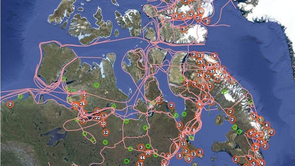
Image from the Pan Inuit Trails Atlas. Source: Pan Inuit Trails, About.
- Native Land Digital is an Indigenous-led organization that incorporated in 2018. The organization represents Indigenous nations and peoples on their own terms and provides a participatory platform for people and communities around the world to map Indigenous territories, treaties, and languages. The map is an ‘evergreen’ project based on user generated content and users can identify errors or submit requests to add nations to the map.
There are also examples of capacity building initiatives to support Indigenous cartographers. The Firelight Group provides culturally appropriate training in geospatial technologies for Indigenous cartographers, communities, or organizations. The organization holds annual Indigenous mapping workshops to train Indigenous community mappers. It also provides networking and learning opportunities through a global network of Indigenous cartographers known as the Indigenous Mapping Collective. Since 2014, Indigenous mapping workshops have trained over 1000 Indigenous community mappers on geospatial tools and technologies.
Select Initiatives to Re-establish Indigenous Place Names
In Canada, geographical naming is the responsibility of the province or territory where the feature to be named is located. In the case of federal lands, such as national parks, place names are the joint responsibility of provincial, territorial, and federal naming authorities. The national coordinating body responsible for standards and policies on place names, known as the Geographical Names Board of Canada, has recently worked with Indigenous groups to restore Indigenous place names.
Today, Indigenous peoples are working towards the re-establishment of their place names:
- A Committee comprised of 17 Indigenous women worked with Elders and community members to identify and propose Indigenous place names for some wards in the City of Edmonton. A bylaw approving the Indigenous ward names was passed on 7 December 2020.
- The Labrador Innu have been working for decades to document place names in their homelands.
- The Inuit Heritage Trust highlights traditional Inuit place names on maps and aims to ensure that they are made official in Nunavut.
- Potawatomi cartographer Dr. Margaret Wickens researched and designed a map of Canada without boundaries, displaying only Indigenous place names. The map does not depict all Indigenous place names in Canada, as it includes those shared with permission by First Nations, Inuit and Métis people and communities. As explained in a description of the map: “The names express territorial rights and describe the shapes, sounds, and stories of sovereign lands. The names mark the locations of the gathering places, the communities, the places of danger and beauty, and the places where treaties were signed. The names are ancient and recent, both in and outside of time, and they express and assert the Indigenous presence across the Canadian landscape in Indigenous languages.”
- Maps are a key feature of some modern treaties negotiated between Indigenous groups and federal and provincial and/or territorial governments. Maps are used to identify Indigenous territories and land, resources, or water rights within a particular area. In some cases, modern treaties contain provisions concerning place names. For example, through a modern treaty, the Nunatsiavut Government in northern Labrador has the power to select place names, recognize alternative place names, rename places and determine the suitability of place names in Labrador Inuit lands.
Through these and other initiatives, Indigenous peoples are putting their perspectives, stories, and histories on the map for future generations.
Additional Resources
Adam Gaudry, “Maps,” Indigenous Peoples Atlas of Canada.
Christina Gray and Daniel Rück, “Reclaiming Indigenous Place Names,” Yellowhead Institute, 8 October 2019.
Government of Canada, Stories from the Land: Indigenous Place Names in Canada.
*Disclaimer: The examples provided in this HillNote are for illustrative purposes only and do not imply official endorsement and acceptance of the boundaries or names shown on these maps by the Library of Parliament.
Author: Brittany Collier, Library of Parliament
Categories: Education, language and training, Indigenous affairs